Parking: End of Denning Rd, Claryville, NY 12725
Distance: 24.4 miles
Time: 2 days, 1 night
Gear:
- overnight pack
- 2L of water
- Meals and snacks for 2 days
- Pocket Rocket stove, Pinnacle Soloist cook-set, utensils
- First aid, tape, multi-tool, headlamp, 550 cord, carabiner
- Sawyer Squeeze Mini water filter and 16 oz. 'dirty' bag
- Casio Patherfinder Watch with compass, altimeter and barometer
- Counter Attack Bear Spray
- Smartphone for GPS and camera
- Tarptent Protrail with ground sheet
- Kelty 40° Sleeping Bag
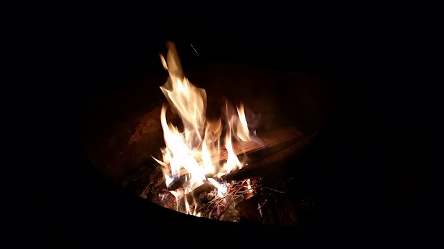
- Firestarters, lighter
- Trekking poles
- Map - New York New Jersey Trail Conference #142
- Trail running shoes
- NO COTTON - Why no cotton? Cotton is a thicker material and isn't as breathable as synthetic materials. Once it's wet, it becomes heavier and takes longer to dry.
After completing the 35 high peaks of the Catskills, I am looking to turn my attention to gaining some mileage. Long distance hiking over difficult terrain with your needs on your It back has always been of great interest to me. There is so much to observe while traveling on your own two feet.
Time is a fickle thing. It can be hard to come by when you need it; extinct when you want it. Carving out hours for my trips to the wilderness has not allowed me to trek for longer than 4 days at a time. With this limited time frame, one-nighters such as this one can satisfy my yearning for a short while (without using vacation days).
This loop is a common one taken by many; typical mileage is about 15 from a different parking lot. I chose to start at a trailhead further to the south in order to add miles. Day one would be significantly easier (and shorter) than day 2.
From Denning Rd I started on the yellow Phoenicia East Branch trail (PE). The first 6 and a half miles or so is nothing more than rolling hills. This puts me at the Oliverea Rd/Giant Ledge parking area. The trail gets steep as the elevation increases right off the road. After .75 miles the blue Giant Ledge-Panther trail (GP) begins/terminates to the left. The incline continues with little compassion. As I make my up the blue GP, a spring provides me with an opportunity to top off my water supply for the remainder of the day and night. I will be back tracking in the morning so I can detour again.
 |
| This blue trail towards the high peaks is the Curtis-Ormsbee trail. I will be returning from this direction the next day |
 |
| This is the Slide Mountain Park Area. The next 1.95 miles is a road walk. |
 |
| Here is the left turn up the GP trail. |
 |
| Not all water sources are so well marked. |
 |
| Trail maintenance volunteers put this hose here to reach where the water is literally coming out of the mountain. It also makes for an easy fill with its directed flow. |
If you're wondering how I process water on the trail, click here to read my review of the Sawyer Squeeze Mini water filter. It is an essential piece of gear.
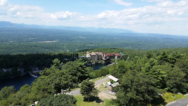
The Giant Ledges are a series of rock ledges with expansive views to the east. These views are some of the best in the Catskills and attract lots of visitors in the warmer months. Nearby and off the trail is a primitive camping area which would become very crowded this particular weekend. It is one of the reasons why I prefer to make camp kind of early - to secure a (good) spot before everyone else. The previous visit to this campsite found me alone - nary a human around for 12 hours. THAT was nice; views all to myself without the noise of day-trippers.
 |
| These yellow campsite markers are used by the NYS DEC to label maintained campsites along the trails. The Catskills does allow wilderness or at-large camping so long as each party complies with state regulations. |
 |
| My tent is an ultralight solo shelter I use for 3 season camping and backpacking. |
I set up around 3 o'clock in the afternoon. There was nobody else at the campsite. Sunset was not until 8-ish so I had plenty of time to nap, meditate and take some more photos of this gorgeous environment. And snack =)
As the afternoon turned to evening, several groups of hikers showed up looking for room to stay the night. There was a group of 4 or 5 that took a nice spot to my left; then came the kids. Teenagers. A bunch of little jerk-offs, for lack of a better term. Loud, obnoxious and inappropriate was the behavior I have seen before in these kinds of groups. This pack did not disappoint. After the young'ins came through there was a couple, a trio and another solo hiker. I estimate there were over 50 people spread about.
Like I said, the ledges are a hot spot.
The next day I woke early to get a head start. There were a lot of miles to cover and rough terrain to traverse.
From the spring below the ledges I continued back to the trail junction where I would turn left onto the PE trail towards Woodland Valley Campgrounds. The path gradually moved to lower elevations, however I knew there would be a steep incline from my review of the map. After about a mile and a half I came upon my incline; it was more like a huge set of stairs. Despite the constructed nature of the rocks walking up them wasn't any easier. Less than a mile later and a few hundred feet closer to sea level I would arrive at the Woodland Valley Campground.
The campground is a state run facility offering campsites suitable for tents and small campers. You can reserve a campsite by going to www.reserveamerica.com and searching 'Woodland Valley, NY'. Bathrooms, showers and running water provide what I think is really a 'glamping' experience without the nice RV. I like the woods.
 |
| The trail splits two campsites at the far end of the campground |
 |
| Cairns are your friend. Follow them. |
Just passed this rock is a stream crossing and trail intersection. The red blazed Wittenburg-Slide trail begins, or ends here. It is 3.9 miles to the summit of Wittenburg Mountain which has arguably the finest view from any of the Catskill 3500 high peaks.
 The trail heads up from here and rises to around 2,200 feet. Shortly after I crossed the bridge (maybe a quarter of a mile) I glimpsed a very large black bear right on the trail. The instant my brain registered what I was seeing it dart off into the bush. As I proceeded (bear spray at the ready) I call out to the bear in an even tone "hey bear, hey bear". He or she needs to know I am close by and just passing through. As I call to it I can hear it moving further away until all I can hear is the wind. The bear spray returns to its holster and I trek on.
The remaining 1.6 miles to the next trail junction alternate between rolling and kind of level terrain. This little stretch is really just a nice walk in the woods.
Once at the intersection I take a short break to snack on some trail mix and catch my breath. I would need it. The next 1.3 miles were steep and unforgiving.
 |
| The trail winds around this tree and up over these rocks; basically climbing. |
As the grinding climb comes to an end I glimpse through the trees to my left for a teaser of the payoff view to come...
There is no reveling in this view. Though open and beautiful, it was just a pit stop on my hike. I had plenty more elevation to lose and gain as I make my way to the tallest mountain in the region. Before I could reach Slide Mountain I had to go up and over Cornell first. The col - a saddle between mountains - between Witt and Cornell is not overly strenuous. There are some very steep parts but not many.
Just 30 minutes after departing Wittenburg Mountain I reached the peak of Cornell Mountain, which is right before this view. This is the point at which the trail begins its descent.
 |
| The destination ahead: Slide Mountain, highest peak in the Catskills |
 The distance from Cornell to Slide is about 2.3 miles; the final .8 being the steep ascent. After losing altitude in between the peaks I begin to fatigue. I was running low on water and feeling the loss of energy that comes with dehydration. There is a water source right before the summit. Rationing my remaining water supply, I traveled slowly up the tall mountain salivating at the thoughts of that fresh water.
With my water and physical energy on empty, I finally made it to the fairway leading to the liquid of life. I sat and got fat on water for 20 minutes after a tough trek up a tough mountain.
 |
| A view from the trail of Wittenburg (L) and Cornell (R) on the way up to Slide. |
 |
| Water to the right! |
 |
| Its hard to see it but the water is flowing from a tube just above the rock on the upper left |
 |
| A better view of Witt & Cornell. |
 |
| Top of Slide Mountain, 4,190 feet above sea level. |
My final climb of this trip complete, I rested at Slide for a bit; I still had 5.5 miles to complete before reaching the Denning Rd parking area.
Continuing the hike, I descended gently on the red Witt-Slide trail for a short while before reaching the blue Curtis-Ornsbee trail. A left turn here and another descent begins, this one for just over a mile and a half. The next junction would mark the final turn, another left onto the Phoenicia East Branch trail.
Easy goings on this yellow blazed path for the final 2.95 miles was a nice reprieve from a tough day with a lot of elevation gain. The first day of this trip only saw about 8.5 miles. This second day entailed 15-16 miles and 3 of the Catskills highest peaks. THAT is what I call a great day on the trails!


Always great to see your excursions and hear your insight!
ReplyDelete