Kaaterskill High Peak

Parking: 42.170966, -74.113324 Dead end at Gillespie Rd, Elka Park, NY 12427
Distance: 6-7 miles
Time: 4-6 hours

Pictured above is the route I took to summit KHP; it consists of a bit of bushwhacking (marked in blue) and an easy snowmobile trail (marked in red). The star on the left represents the parking lot; on the right is the top of the mountain. The snowmobile trail winds its way around the High Peak and its smaller neighbor to northwest, Round Top Mountain. There is a game trail that leads up the steep southern slope and down the north side (dashed line), which has a more reasonable yet strenuous grade and reconnects with the snowmobile trail. The black star was a surprise to me. An eerie, unexpected encounter.
From the parking area I headed southeast for a few minutes before turning left towards east-northeast. I gave myself a bearing that would cut across the snowmobile trail. It would be a few miles through intermittent bush and clearings. As I began to gain elevation I consulted the map to see at what elevation lies the trail. I made a mental note and kept moving. A short while later I checked the altimeter on my Casio Pathfinder watch; 2,600'. The trail is at around 2,800'.
A short time later my new nicks & scratches and I located the snowmobile trail. I saw a red trail marker and obviously that was it. Turning right onto the trail I had about 3 miles before the herd path. The trail rambled along and it was very leisurely. I stopped along the way because I hadn't thus far (over 1 hour into the hike). Its important to take rest breaks while hiking several miles in a day. Taking off your shoes & socks and giving your feet some air for 5 minutes once an hour is good foot care; and my feet are kind of important to my hiking!
 |
| Bear right/straight at this fork |


From my entry point to the red trail, it would take me about 90 minutes to reach where the heard path at the southern approach left the trail. I checked my watch every so often, and when enough time had passed I conferred with my GPS. I wasn't far off and as I scanned for a game trail, I found nothing. The vegetation was overgrown and thick alongside the trail. I found what I thought could be a cairn. There were 3 rocks that appeared to have been placed in a formation. There still was no real sign of a trail. I decided to leave the snowmobile trail here and headed northeast on the rising mountainside. The bearing I set was a straight line towards the summit. It would take me over a number of ledges with outstanding views of the surrounding mountains; and I certainly had to work for it. The distance was short but the angle of the incline was no less than 45°. There were several scrambles and a few climbs several feet off the ground.


 |
| Every hike, every camp. Mike D in the house. |
This is the first ledge. I stopped here to eat lunch, admire the view and to meditate. It was a stupendous day to be outdoors and enjoying my home state of New York.
Due to the number of them I am not sure which one is actually Hurricane Ledge. Either way, the views are gorgeous and they were all created by the same hurricane (supposedly).
 |
| I like to climb but this is beyond my skillset. I found another way around... |
 |
| to check out this view. |


 |
| That's the Hudson River in the distance. |


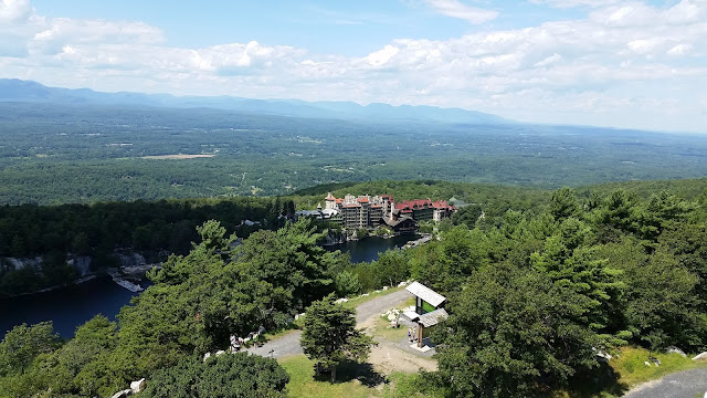
After reaching these two lookouts and a bit more scrambling, the grounds leveled and I had reached the summit. A short trail from the peak leads to a great viewpoint.


This is the summit clearing. From this picture, I came in from the left and the trail continues down to the right of the debris. Behind me is the trail to the viewpoint in the photographs above along with other debris.
The old ammo box holds an unofficial register made of loose papers & receipts. Each was noted with a hiker's name and the date they reached the summit. I found space somewhere and used the pen that was there to sign my name. Seven more to go.
While walking towards the viewpoint with blue skies in sight, a sharp left will lead to a small airplane crash. There was a ghostly feeling to the whole scene; debris was spread pretty far apart. It didn't feel right taking photos any closer than this. Someone died in that wreckage and I think it would be disrespectful to explore it like a tourist.


Leaving the crash site behind, I made my way back to the summit and to the unmarked path that would actually turn out to be marked quite well with cairns. There were a couple of beautiful views on the way down as well.


The descent was gradual, as the north side of the mountain is not as steep as the south side; it would be a nice hike up. Upon reaching the snowmobile trail, I followed the markers, sign and kept to my left over a small crossing. Proceeding straight and to the right would lead to another intersection in the opposite direction.


After a couple of miles I came back to the fork junction from earlier. I kept moving towards the trailhead but I would need to break off and bushwhack the remaining mile or so. Using my GPS I lined myself up with the parking lot. Next, I took my compass and set my bearing. The best way to hold an accurate bearing is to pick a landmark in the distance and travel to it. This is what I did and soon enough I would reach the tall grassy meadow in which I entered the same morning.
My favorite part of this hike was the scrambling ascent of the south face. I like climbing so I found it fun and challenging to take the tough, steep route up. And there was no way I was going down that with a bum knee!

Comments
Post a Comment