Overnight & Bushwhack to 3 Summits
Not many people summit these 3 peaks in 1 hike. I did!

Parking: 42.023863, -74.599799 Balsam Lake Mountain Trailhead, Hardenburgh, NY
Miles: 13-16 depending on route
Hours: 9-11


Gear:


Parking: 42.023863, -74.599799 Balsam Lake Mountain Trailhead, Hardenburgh, NY
Miles: 13-16 depending on route
Hours: 9-11


Gear:
- overnight pack
- 2L of water, 32 oz. Gatorade
- dinner, breakfast, snacks
- first aid
- tape
- knife
- water filter
- Casio Patherfinder Watch with compass, altimeter and barometer
- Counter Attack Bear Spray
- smartphone for GPS
- ultralight tent with ground tarp
- sleeping bag
- extra layers - fleece, socks, shirts, hat, Buff headband, windbreaking jacket
- firestarters
- trekking poles
- map - New York New Jersey Trail Conference #142
- hiking boots
- NO COTTON - Why no cotton? Cotton is a thicker material and isn't as breathable as synthetic materials. Once it's wet, it becomes heavier and takes longer to dry.
This was a really tough hike. Studying the map prior to this outing I knew the terrain would be steep. You can get an idea by reading the topography but you never really know until you're staring at a 45° incline that you need to climb.
Doubletop, Graham and Balsam Lake Mountains are located in western Ulster County, about 15 miles south of Margaretville. There are no trails that lead to Doubletop as it sits in pure Catskills wilderness. Graham has an unmarked trail from the west off of the blue Dry Brook Ridge trail; there are no trails leading to it's peak coming from the east. Balsam Lake Mountain and its fire tower are located on trail about 1.5 miles from the trail head, heading north.
I had planned to do this hike from the parking lot in one day, but I was lazy and didn't feel like getting out of bed early to reach the trailhead by 8am; so, I arrived around 1:30 p.m. and camped out along the yellow Neversink-Hardenburgh trail. There is a primitive campsite on the map but it is not marked along the trail with the usual state campsite marker. There was a tepee set up from a few sticks and branches that denoted an area to bed down. I missed it at first but clearly recognized it after I turned around. The hike in was 2-3 miles of easy rolling earth and took about an hour and a half at a leisurely pace.
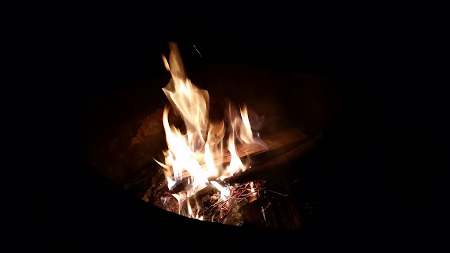
With plenty of time to relax, I set up my tent and went about cleaning the fire ring that looked like it hadn't been used in a while. Typically you are not permitted to camp within 150 of any water source, but this was a designated site. What I hadn't expected were the gnats and flies. This motivated me to get a fire started as soon as possible, as the smoke would drive them away.


 |
| Turn left at this sign and head up the road |


As the bugs retreated and the fire died, I lay in meditation in my tent for a while. The sounds of the wind and birds and nothing else is incredibly calming. A short distance away I could hear the rushing water of the Beaver Kill. The natural sounds of silence are absolutely wonderful.
After more wood gathering and organization, I opened up a package of organic chicken and apple smoked sausage. I whittled a sharp edge from a medium sized stick and got to cooking. The sausage cracked and popped as it heated up; oily juices secreting and dripping into the fire. The heat cooks it fast and the flames char it even faster.
About an hour later I was finished without haste. I fed the fire as the sun set, anticipating the stars that would be visible as the Earth rotated and revolved. I sat in meditation again, this time beside the fire. As the temperature began to fall I caught a slight chill and slowly came out of my tranquility session. The heat radiating from the fire felt great. Stepping just a few feet back I could feel the cold, no hint at all of the fire's energy.
As time passed and night fell, I lay in peace, staring up at the stars as they burn millions of miles away. I was hoping for a bright moon, and it showed itself just as I felt tired enough to retire for the night. I thought I might rise at 1 or 2 a.m. to restart the fire and catch the moon, but I was too cold and bundled in my bag. Maybe next time.
Tossing and turning I woke just before 6 a.m. and started the day; I had a lot of work to do. Breakfast consisted of a protein bar and trail mix sitting by a morning fire. I walked to the creek and topped off my water supply; camp was broken down and I departed by 7:30.
Back on the yellow trail, I followed it until it split from the Beaver Kill. This is where the bushwhack would begin. I decided to follow alongside the water for a little less than a mile. I hit the remnants of a dry waterway and followed this east as I gained elevation. At around 3,200' I turned slightly north. Checking my GPS I confirmed I was on course with the southeastern lower summit of Doubletop Mountain. The climb wasn't overly steep at this point but the ground was uneven and unsettled. Leaves, rocks and dirt slipped from beneath my steps. Passing 3,500' there was a small brow in the mountainside which allowed me a chance to catch my breath. Pressing forward, the final 200+ feet was the steepest and thickest brush thus far.
After reaching the summit ridge I searched for a the viewpoint that was noted on the map. I didn't manage to find it, but I did peak through the trees to see across the valley.
Turning around and heading northwest, my destination was the canister. The mountain top was thick with pine trees and dried branches all looking to stab and scratch me as I broke them off. I found the summit register with relative ease. I sat down for a break as I put my name to yet another Catskill 35 peak.


It took me about 3 hours to reach the summit from my campsite. Conferring with and planning a route on the map, it was about 10:45 when I left Doubletop in a northwest direction towards Graham Mountain. I could see it through the trees and along part of my descent. It looked imposing from such a close distance. Little did I know that this would be the toughest part of the day.

The way down was again unsteady and kind of steep. There were however, nice views that couldn't be seen in late spring and summer. I plummeted to an elevation of about 2,800'. I glanced up to see what would be my first very steep hump on the way up. As I reached the top the terrain leveled somewhat and I could see just ahead was another steep and rocky slope. This would be the pattern. I lost count, but there must have been 5 or 6 of these steep slopes and brows. Each time I conquered one, there was another, and another. These pitches were relentless; very steep, rocky and completely unforgiving. I had crawled and scrambled many times to get myself up the mountain, rock and soil giving way several times and causing me to slide down the hill a few feet.
Losing track and not caring anymore of how many steep climbs I would make, it appeared to me that I had reached the summit ridge. My bearing was dead nuts, as the peak was straight on, west 270°.
At 3,868' it is the 7th highest in the Catskills. Part of it, including the summit is on privately owned land. At the top are the ruins of an old relay station built and abandoned in the 1960's. The station was intended for Instructional Television, a predecessor to today's Public Broadcasting System. I rested here and ate lunch, feeling accomplished and beat up. Scratches adorned my arms and neck while bruises were festering on my legs. The sweat soaked shirt I changed was a sign of hard work and determination.


 |
| Looking back at Doubletop Mountain from one of the many levels on way up Graham. |


Back on trail! After 5+ hours of trekking through the bush wilderness, I would be traveling on trail the rest of the day. Gathering my pack I took off for Balsam Lake Mountain and its fire tower. The unmarked trail leading to the blue Dry Brook Ridge trail was an easy 1.5-2 miles. It was rocky and soggy in a few spots as it went down off the summit and then gently back up. In less than an hour I reach the blue trail.

 |
| This is the intersection with the blue trail, as it comes in from the right. Bear left and continue straight. |

Next junction was about .25 miles away and would be the red blazed Balsam Lake Mountain trail. Bearing right here, I had another .75 miles to my final summit of the day. It wasn't without a little pain though. There wasn't much elevation to climb, but my legs and feet were on fire. Each time I hit a slope my pace slowed to a crawl. There were 3 or 4 inclines that strengthened my resolve to not stop until I reached the fire tower, no matter how slow I moved. Not stopping is the key. It doesn't matter how much your pace is reduced; as long as you keep moving your winning.
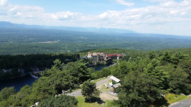
After about 20-25 minutes, I made it. My 3rd Catskill 35 of the day, and I would soak up the best views of the day as well. The last climb was up the fire tower to look down on one of the most beautiful regions in New York.


The final hike down to the parking lot would be steep along the red trail. Things would ease up quite a bit at the final intersection, making a right onto the blue Dry Brook Ridge once again. After just a mile and a half, I was back at my car. Feeling tired but energized, I made the walk back to the trail register and signed out where I began the day before.
This hike will definitely go down as one of my toughest. Maybe it would've been easier if I had only a daypack and not my overnight bag!


Awesome!!!
ReplyDeleteThank you! I loved every minute of it.
Delete