Schunemunk Mountain State Park
Some nice views and steep slopes make for a surprisingly nice hike.

Parking: 41.407578,-74.081696 Taylor Rd, New Windsor, NY
Miles: 9-10
Hours: 5-7

Shunemunk Mountain State Park is made up of state and private land. The summit of 1,664' is the highest point in Orange County, NY. There are 2 ridges that offer significant vistas to the east and west with some steep slopes necessary to climb in order to access them. This is the first time I have visited this park and was pleasantly surprised by the terrain and openness of the ridges. This park allows hunting from October 1st through February 28th and then again in the month of May. It is necessary to wear bright colors when hiking during this time (the typical orange of a hunter is best).
The morning trek would be the most strenuous on the route I had chosen. From the parking lot a trio of trails begin across the street as one: White Sweet Clover, Yellow Jessup and Teal Hudson Highlands. Following this trio for a short distance through an open field, I would turn left on the Sweet Clover at the hunter's parking area. Continuing through another field the trail soon turns right and into the woods. The terrain rises gently, and shortly thereafter reaches the train tracks of the Port Jervis Metro North line. Take caution in crossing this active railway.


After crossing the tracks I turned left onto the red Otterkill trail. I wouldn't be on it for long. The trail ends at the junction with the black Dark Hollow trail in just a few hundred feet on the other side of Dark Hollow Brook. This is where the day's ascent is made. The climb is pretty steady with 2 steeper sections and a few scenic lookouts. Switchbacks relieve the effort somewhat but it is still a nice, strenuous rise.


Taking a short breather for a snack at this 2nd lookout, it wouldn't be far before reaching the yellow Jessup and teal Hudson Highland trail. From here on out the trek would be easy. Bearing left the trail turns into a ridge walk along open rock. Cairns, logs and trains of rock would lead the way from here. About 5 minutes after this intersection comes a white spur trail to the Megaliths, a series of large boulders with a great western view. I sat for a few minutes admiring the landscape while having a bite to eat.


After my break on the Megaliths, I couldn't find the trail back! I took a few minutes searching for a depression in the ground; when I got annoyed I just bushwhacked and found my way back to the rocks and the main trail. Continuing on the ridge I would encounter a few more clear viewpoints before coming to the orange Western Ridge trail (right turn). The west ridge is lower in elevation and unbeknownst to me, there would be a very steep and rocky descent. I think I may come back in the future and hike a different route in reverse so that I can come up this scramble.


Looking at the view up as I came down conjures scrambling dreams...


In between the ridges is Perry Creek. I sat here for a few minutes and filtered some water that would take me through the rest of the day. The terrain here was pretty level and the hike up to the next ridge was very gradual. There weren't many views here that I hadn't seen from the higher eastern ridge. Much of this section of trail is on private property. It is only right to respect the landowner here; leave no trace always applies, stay on trail and don't relieve yourself until your return to state land.
A mile or so from the creek is a nice view of the east ridge. There are 2 trails that terminate before this viewpoint. I stopped here for lunch.


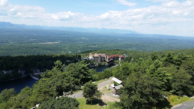
After an abbreviated lunch stop I continued on the orange trail along the Western Ridge. The white Sweet Clover trail ends at a junction about a half mile from where I ate lunch. Proceeding past this intersection along the rocks, some views open up and I could see the Hudson River. As I reached the red Barton Swamp Trail (turn right), I could see the Newburgh-Beacon Bridge and what I believe is Storm King Mountain and Breakneck Ridge.


After a short distance the trail begins to descend steeply. At the base of the descent is a stream crossing, followed immediately by a left turn onto the yellow Jessup-teal Hudson Highlands trail. The way down is gradual but littered with leaves which make each step a little unsure. I was constantly slipping and tripping over the rocks beneath the leaves.
After a mile or so I had made my way down to the railroad tracks. From here the trail crosses over the red Otterkill. Sticking to the yellow and teal, I followed it across the tracks and down a bit to what appeared to be an old woods road. Traveling parallel to the tracks for maybe half a mile, the trail turns left and proceeds down towards the open fields that I had first traversed on my way into the woods. Soon thereafter I was back at the trail head.


I completed this hike in under 6 hours. I use a Fitbit Charge to track my hikes. Based on my height it converts a certain number of steps to a mile. According to the device, I had hiked over 10 miles. Pretty good pace.

Parking: 41.407578,-74.081696 Taylor Rd, New Windsor, NY
Miles: 9-10
Hours: 5-7

Shunemunk Mountain State Park is made up of state and private land. The summit of 1,664' is the highest point in Orange County, NY. There are 2 ridges that offer significant vistas to the east and west with some steep slopes necessary to climb in order to access them. This is the first time I have visited this park and was pleasantly surprised by the terrain and openness of the ridges. This park allows hunting from October 1st through February 28th and then again in the month of May. It is necessary to wear bright colors when hiking during this time (the typical orange of a hunter is best).
The morning trek would be the most strenuous on the route I had chosen. From the parking lot a trio of trails begin across the street as one: White Sweet Clover, Yellow Jessup and Teal Hudson Highlands. Following this trio for a short distance through an open field, I would turn left on the Sweet Clover at the hunter's parking area. Continuing through another field the trail soon turns right and into the woods. The terrain rises gently, and shortly thereafter reaches the train tracks of the Port Jervis Metro North line. Take caution in crossing this active railway.


After crossing the tracks I turned left onto the red Otterkill trail. I wouldn't be on it for long. The trail ends at the junction with the black Dark Hollow trail in just a few hundred feet on the other side of Dark Hollow Brook. This is where the day's ascent is made. The climb is pretty steady with 2 steeper sections and a few scenic lookouts. Switchbacks relieve the effort somewhat but it is still a nice, strenuous rise.
 |
| Proceed straight on the red Otterkill trail |


Taking a short breather for a snack at this 2nd lookout, it wouldn't be far before reaching the yellow Jessup and teal Hudson Highland trail. From here on out the trek would be easy. Bearing left the trail turns into a ridge walk along open rock. Cairns, logs and trains of rock would lead the way from here. About 5 minutes after this intersection comes a white spur trail to the Megaliths, a series of large boulders with a great western view. I sat for a few minutes admiring the landscape while having a bite to eat.
 |
| This is the intersection of the black Dark Hollow and Jessup-Hudson Highlands |


After my break on the Megaliths, I couldn't find the trail back! I took a few minutes searching for a depression in the ground; when I got annoyed I just bushwhacked and found my way back to the rocks and the main trail. Continuing on the ridge I would encounter a few more clear viewpoints before coming to the orange Western Ridge trail (right turn). The west ridge is lower in elevation and unbeknownst to me, there would be a very steep and rocky descent. I think I may come back in the future and hike a different route in reverse so that I can come up this scramble.
 |
| Junction with the blue Ridge-to-Ridge trail. Continue straight on the teal and yellow. |


Looking at the view up as I came down conjures scrambling dreams...


In between the ridges is Perry Creek. I sat here for a few minutes and filtered some water that would take me through the rest of the day. The terrain here was pretty level and the hike up to the next ridge was very gradual. There weren't many views here that I hadn't seen from the higher eastern ridge. Much of this section of trail is on private property. It is only right to respect the landowner here; leave no trace always applies, stay on trail and don't relieve yourself until your return to state land.
A mile or so from the creek is a nice view of the east ridge. There are 2 trails that terminate before this viewpoint. I stopped here for lunch.


 |
| One of the few tree stands for hunters I spotted along the way |


After a short distance the trail begins to descend steeply. At the base of the descent is a stream crossing, followed immediately by a left turn onto the yellow Jessup-teal Hudson Highlands trail. The way down is gradual but littered with leaves which make each step a little unsure. I was constantly slipping and tripping over the rocks beneath the leaves.
After a mile or so I had made my way down to the railroad tracks. From here the trail crosses over the red Otterkill. Sticking to the yellow and teal, I followed it across the tracks and down a bit to what appeared to be an old woods road. Traveling parallel to the tracks for maybe half a mile, the trail turns left and proceeds down towards the open fields that I had first traversed on my way into the woods. Soon thereafter I was back at the trail head.


I completed this hike in under 6 hours. I use a Fitbit Charge to track my hikes. Based on my height it converts a certain number of steps to a mile. According to the device, I had hiked over 10 miles. Pretty good pace.

Comments
Post a Comment