Catskills 3500: 3-Peak Loop
Conquer fifteen miles and 3 peaks over 3500' while getting a taste of the Devil's Path.

Parking: 42.184158,-74.272180 Spruceton Rd, West Kill, NY
Miles: 15
Hours: 8-10
Gear:
The 3 peaks to summit on this hike are West Kill, Southwest Hunter and Hunter Mountains. Southwest Hunter is reached via unmarked trail, however it is easily followed. If you start early enough (which I did not) you can bushwhack your way to Rusk Mountain, another 35er. This one is totally trail-less and requires some navigation skills along with GPS.
I started this hike at the end point so my car was waiting for me as I came off the trail. Leaving the parking lot and walking eastbound along Spruceton Rd, the blue Diamond Notch trail is .3 miles ahead. From here it is an easy trek to the first junction at Diamond Notch Falls that parallels West Kill Creek.


This is where you turn onto the Devil's Path for the climb to West Kill Mountain (crossing the bridge and hanging a right). The ascent is steep and unyielding, a continuous escalator of rock and earth teaching one the reason this trail is so aptly named. After about a mile and a half you will reach 3500' in elevation and an unmistakable rock overhang. This is the midway point to the summit.


Pressing on with the steady rise of the trail for another mile, a can't miss viewpoint is evident on the left with fantastic southern views. There is another scenic outlook with views to the north opposite this one. Look for the depressed path in the ground and follow it to daylight. Take in the scenery at these lookouts, for the summit is just a bit further and marked with a cairn on the right.


After a short break I carried on and backtracked to the Diamond Notch Falls trail junction. Crossing the bridge again and continuing on the Devil's Path, my destination would be Southwest Hunter Mountain (but not before another scenic view). For about 3/4 of a mile the trail rises steadily before it takes on an arduous profile. There is no let up. Continuously climbing for another 3/4 brought me to another lookout rock dubbed Geiger Point. The view was not nearly as impressive as the last, but it provided a nice spot to stop and rest. The path's impression on the ground and break in the trees is what caught my eye. I spied the cairn and log marking its location afterwards.


When I was rested and ready to continue, I proceeded towards the unmarked path shown on the map. I imagined there would be a cairn and obvious track marking the turn, and I was right. This trail is very easy and very straight. The junction where the path turns up the mountain is again marked by cairns and blocks your procession forward. The rise is short and terminates at a small clearing where the summit register is located. I signed the logbook to document my ascent, then retraced my steps to the Devil's Path.


The day got much easier following this summit. The remaining trails had little to no rise. Shortly after rejoining the red marked Devil's Path I stopped for lunch at the Devil's Acre lean-to. There is an active spring nearby where I topped off my water supply. From here I merged onto the yellow Hunter Mountain trail. The next intersection was 1.3 miles away; before heading to Hunter via the blue Spruceton trail I took a small yellow offshoot to another viewpoint.


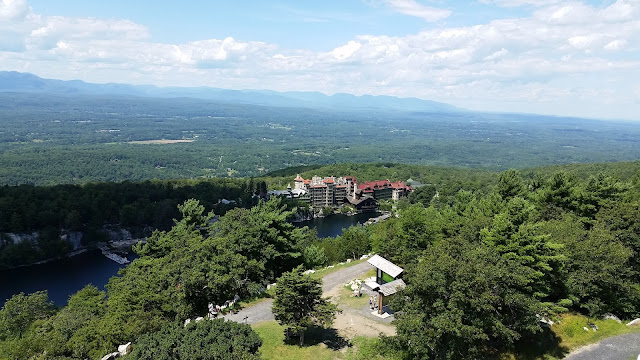
Hunter Mountain is just .4 miles away. The ski area of Hunter is located on the mountain's northwestern side which has been named the Colonel's Chair. There is a mile long trail leading to this summit off the Spruceton trail. The fire tower and observer's cabin at the true summit have only recently been restored and reopened for public use. Climb to the top of the tower (+4,100') for magnificent views of the surrounding area. This is the second tallest of the Catskills 35 at 4,040' above sea level.


The blue Spruceton trail is essentially a carriage road and is also traveled on horseback. It is of gravel & dirt and wide enough for a car or horse drawn carriage. The descent is easy and uneventful. Along the way down, there is the trail for the Colonel's Chair, the John Robb lean-to and a spring. There was also an interesting rock whose profile resembled that of a man.


Coming to the end of the gravel and dirt path is a trail sign and left turn. The parking area is 1.7 miles from here.


Rusk Mountain is nearby and accessible by bushwhack. By the time I had reached the base of this mountain it was already 4 o'clock. Sunset was in less than 2 hours and I did not think I could make it up and down in time. I will save that summit for another day. Fifteen miles and 3 peaks will have to do for this hike!

Parking: 42.184158,-74.272180 Spruceton Rd, West Kill, NY
Miles: 15
Hours: 8-10
 |
| The parking lot is the end of my hike. |
Gear:
- daypack
- 3L of water
- lunch, snacks (more than usual due to the high mileage)
- first aid
- tape
- knife
- water filter
- compass
- trekking poles
- windbreaker and layers for warmth
- map - New York New Jersey Trail Conference #141
- hiking boots
- NO COTTON - Why no cotton? Cotton is a thicker material and isn't as breathable as synthetic materials. Once it's wet, it becomes heavier and takes longer to dry.
The 3 peaks to summit on this hike are West Kill, Southwest Hunter and Hunter Mountains. Southwest Hunter is reached via unmarked trail, however it is easily followed. If you start early enough (which I did not) you can bushwhack your way to Rusk Mountain, another 35er. This one is totally trail-less and requires some navigation skills along with GPS.
I started this hike at the end point so my car was waiting for me as I came off the trail. Leaving the parking lot and walking eastbound along Spruceton Rd, the blue Diamond Notch trail is .3 miles ahead. From here it is an easy trek to the first junction at Diamond Notch Falls that parallels West Kill Creek.

 |
| This is the parking area .3 miles down the road where the Diamond Notch trail begins. |


This is where you turn onto the Devil's Path for the climb to West Kill Mountain (crossing the bridge and hanging a right). The ascent is steep and unyielding, a continuous escalator of rock and earth teaching one the reason this trail is so aptly named. After about a mile and a half you will reach 3500' in elevation and an unmistakable rock overhang. This is the midway point to the summit.


 |
| Yup, icicles already! |

Pressing on with the steady rise of the trail for another mile, a can't miss viewpoint is evident on the left with fantastic southern views. There is another scenic outlook with views to the north opposite this one. Look for the depressed path in the ground and follow it to daylight. Take in the scenery at these lookouts, for the summit is just a bit further and marked with a cairn on the right.
 |
| Southern views |


 |
| Northern views |


After a short break I carried on and backtracked to the Diamond Notch Falls trail junction. Crossing the bridge again and continuing on the Devil's Path, my destination would be Southwest Hunter Mountain (but not before another scenic view). For about 3/4 of a mile the trail rises steadily before it takes on an arduous profile. There is no let up. Continuously climbing for another 3/4 brought me to another lookout rock dubbed Geiger Point. The view was not nearly as impressive as the last, but it provided a nice spot to stop and rest. The path's impression on the ground and break in the trees is what caught my eye. I spied the cairn and log marking its location afterwards.


When I was rested and ready to continue, I proceeded towards the unmarked path shown on the map. I imagined there would be a cairn and obvious track marking the turn, and I was right. This trail is very easy and very straight. The junction where the path turns up the mountain is again marked by cairns and blocks your procession forward. The rise is short and terminates at a small clearing where the summit register is located. I signed the logbook to document my ascent, then retraced my steps to the Devil's Path.


The day got much easier following this summit. The remaining trails had little to no rise. Shortly after rejoining the red marked Devil's Path I stopped for lunch at the Devil's Acre lean-to. There is an active spring nearby where I topped off my water supply. From here I merged onto the yellow Hunter Mountain trail. The next intersection was 1.3 miles away; before heading to Hunter via the blue Spruceton trail I took a small yellow offshoot to another viewpoint.


Hunter Mountain is just .4 miles away. The ski area of Hunter is located on the mountain's northwestern side which has been named the Colonel's Chair. There is a mile long trail leading to this summit off the Spruceton trail. The fire tower and observer's cabin at the true summit have only recently been restored and reopened for public use. Climb to the top of the tower (+4,100') for magnificent views of the surrounding area. This is the second tallest of the Catskills 35 at 4,040' above sea level.


The blue Spruceton trail is essentially a carriage road and is also traveled on horseback. It is of gravel & dirt and wide enough for a car or horse drawn carriage. The descent is easy and uneventful. Along the way down, there is the trail for the Colonel's Chair, the John Robb lean-to and a spring. There was also an interesting rock whose profile resembled that of a man.


 |
| Man in a rock. |


Rusk Mountain is nearby and accessible by bushwhack. By the time I had reached the base of this mountain it was already 4 o'clock. Sunset was in less than 2 hours and I did not think I could make it up and down in time. I will save that summit for another day. Fifteen miles and 3 peaks will have to do for this hike!

Comments
Post a Comment