Tri-State Loop, Mt. Washington State Forest, MA
Skirt the borders of New York, Massachusetts and Connecticut while being treated to beautiful views of each state.

Parking: Mt. Washington State Forest HQ 162 East Street Mt. Washington MA.
Miles: 13-14
Hours: 6-9 Hours or overnight

What I took:

Begin your hike by signing in at the register (to the left of this white mini-bus). There is one for day hikers and one for campers. I would be camping, so I signed the camping log. The Alander Mountain Trail begins nice and easy before crossing a bridge and some rocky streams. The Charcoal Pit will come in on your left, then in another 1/4 mile the Ashley Hill Trail; proceed forward at both intersections to the camping area (1 mile past Ashley Hill).

Prior to the camping trail you will cross over a wooden bridge and nice looking stream; signs will be posted for the campsites just like those of the trail intersections.


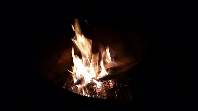
As soon as you turn onto the camp trail the sites become obvious. Numbered from 1-7, each campsite comes with a fire ring and grill top, picnic table and open space for tent setup. The ground is sloped a bit, so try and find the flattest area possible.


Take notice of the large metal storage lock boxes, appropriately named Bear Boxes. I HIGHLY RECOMMEND PUTTING YOUR FOOD AND ALL FRAGRANT GEAR INTO ONE OF THESE BOXES - I HAD A BLACK BEAR VISIT ME THAT NIGHT!!
So, here is my one and only black bear encounter in my life on the trails. It was about 11 pm and I was sitting by the fire, letting it die down before I went to sleep. I had been hearing rustling leaves since sundown, and quick scans with my headlamp yielded nothing. This is typical, as what I am hearing is usually a raccoon, opossum or something small and nocturnal. I tuned it out and continued to relax by the fire. The rustling noises would come closer and closer, sounding more like lumbering footsteps. I scanned my headlamp back and forth again. That's went I met the gaze and glowing white eyes of what I am 99% was a black bear! He was about 100 yards or less from where I was sitting. We stared each other down until the light began to bother him. I could almost make out the distinct shape of a bears head and snout. I couldn't believe it. He shook his head left to right, at one point lifting a leg and paw to a tree to escape the lamp's light. There was no way this was not a black bear, I told myself. As I flickered my headlamp on and off, he began to move towards my right flank, all the while glaring curiously towards me and my campsite. The noises I was making did not seem to deter him. As dark as it was I was sure I could see his every step. He stopped moving and stared in my direction, directly in front of me less than 50 yards away now. Sitting on the opposite side of the fire I decided "I'm fk'g outta here!" I retreated to the false safety of my tent and waited. He was getting closer and closer. I did not want to peak through my tent's door, for fear he would see me and head right for me. It sounded like he was moving aside large branches and limbs in search of food, maybe even pawing the picnic table. The final straw came when I swear he walked right beside the fire and stepped on the grill top. At this point I began to clap; the sounds echoing throughout the forest night. This time I must have been loud enough, because I did not hear any further motion around the campsite. After a few more nervous minutes I managed to lay down and fall asleep. When I woke in the morning I searched my mind for how I was feeling. A bit scared, but more nervous with anticipation as to what would've or could've happened. I know how you are supposed to react when you are encountering a bear, but nothing can prepare you for it actually happening. I counted my lucky stars, had some coffee & oatmeal and shrugged it off.


This is what can happen when you camp in bear country. Be prepared and do not panic; know the protocol. If encountered on the trail, back away slowly while creating lots of noise; stand on a rock if you can and make yourself big - never looking the bear in the eyes. This is usually enough to scare away a black bear. They are typically more scared of humans then we are of them. If you turn your back and run, you will be perceived as prey and will be attacked. Notice the bear's body language; stomping on the ground, huffing breaths and pinned back ears are a sign of an aggravated bear. He is ready to strike. Back away slowly. If you do find yourself in the unenviable position of being attacked, fight back. Punch, kick and use any weapon you can. Playing dead is a misconception and only works against a Grizzly protecting her cubs. Since black bears are great climbers, mama bears will direct the cubs up a tree until the coast is clear. The best protection against any bear is not a firearm, but bear spray. It is a highly irritable pepper spray that will stop the bear immediately upon contact. It must be holstered on your hip, for there is NO time to dig in your pack for it. A 1-2 second burst in a bear's face 10 feet from you will do it. Know when you are in bear territory and prepare accordingly. I didn't have any deterrent so I was lucky the bear moved on. Next time I may not be.

So, now that the evening fun was over, time for the daytime fun. Pack up and head back to Alander Mountain Trail (I did this counterclockwise). About a half mile from the campsite trail, there is a small stream flowing just enough to be used as a water source. There is a sign posted that this is the LAST water source for some time during the dry season. I did not hesitate to top off my reservoir for the long day ahead.
The trail rises steadily until you reach the end of the Alander trail where there is a right turn that is easy to miss, which I did. If you find yourself approaching the cabin, no matter. There is a trail right across the way that leads to a rock clearing. Once you reach this clearing, look right - there is the trail intersection. Proceed to the sign and make a left onto the White South Taconic Trail.
Once through the trees the beautiful summit and ridge of Alander Mountain lay ahead, an elevation of 2,239'. The summit is in Massachusetts, but the views below and in the distance are of New York's Columbia County. There is a set of concrete footings from what used to be a fire tower.


Proceed on the White trail after you've taken in the view and some photos. You will duck in and out of forest and back onto the ridge for a while, passing by the Blue Alander Brook trail and Red Robert Brook trail. Continue on your current path.
After trekking 2.2 miles from the intersection of the Red Robert Brook, you will cross the border into NY and arrive at the Red Mt. Frissel Trail. Continuing straight will lead to Brace Mountain, 2,311'. Barely half a mile, the views are worth the detour. I made my way to this next summit and was pleasantly surprised at what I encountered.


Reaching the summit's rock cairn and flagpole, I was surprised to see a group of para-gliders. Similar to hang-gliding, para-gliding uses a smaller vehicle that you sit on top of as opposed to hanging from. You deploy your parachute and lay it out neatly behind you before taking a running leap off the mountain. I think I have added it to my bucket list.


After Brace Mountain, backtrack to the trail intersection and make a right onto the Red Mt. Frissel Trail. Proceed on this red trail, past the Ashley Hill intersection (you will come back to take this trail).
About a 1/4 past this intersection you will come to the Boundary Monument of 3 states: New York, Connecticut and Massachusetts. Pretty unique I think, to be standing on the border of three different states. Snag some pics and proceed to the CT state high point - Frissel Mountain. A half mile to the summit, you will incur the steepest part of the hike. Once you reach the high point, take a break and sign the logbook located in the military ammo box anchored to a tree.


After you've snacked and rested, retrace your steps to the Ashley Hill Trail and make a right. The trail becomes very easy and level. If you are running low on water or are empty, there will be opportunities to drink and fill from Ashley Hill Brook, parallel to the trail.
Continue on the Ashley Hill Trail for 2.4 miles until you reach the Charcoal Pit Trail. Turn right here and endure just a little more incline before you reach the Alander trail once more. Make a right towards the park HQ as it suggests; another half mile and you are back at the parking lot.

Parking: Mt. Washington State Forest HQ 162 East Street Mt. Washington MA.
Miles: 13-14
Hours: 6-9 Hours or overnight

What I took:
- 2L water (top off at the stream about .5 miles from the campsite)
- Dinner, snacks, breakfast, lunch
- Coffee, Aero Press, coffee filters, sugar
- Overnight pack - 62L capacity
- First aid
- Knife
- Tape
- Compass
- Map - New York New Jersey Trail Conference #107
- Trekking poles
- Synthetic clothing
- NO COTTON - Why no cotton? Cotton is a thicker material and isn't as breathable as synthetic materials. Once it's wet, it becomes heavier and takes longer to dry.
- Hiking boots or trail running shoes
- Sleeping bag
- Sleeping pad
- Inflatable mini pillow
- Tent
- Ground tarp/tent footprint
- Headlamp
- mini lantern
- 550 Para cord
- Carabiners
- Stove
- Cook-set
- Waterproof matches, lighter
- Vaseline/petroleum jelly lathered cotton balls
- Water filter
- Bug repellent (spring and summer trips)
- Mini lightweight shovel
- Hand wipes
- Lightweight rain shell
- Washcloth
- This is MY list – add or subtract depending on your likes/needs

Begin your hike by signing in at the register (to the left of this white mini-bus). There is one for day hikers and one for campers. I would be camping, so I signed the camping log. The Alander Mountain Trail begins nice and easy before crossing a bridge and some rocky streams. The Charcoal Pit will come in on your left, then in another 1/4 mile the Ashley Hill Trail; proceed forward at both intersections to the camping area (1 mile past Ashley Hill).

Prior to the camping trail you will cross over a wooden bridge and nice looking stream; signs will be posted for the campsites just like those of the trail intersections.


As soon as you turn onto the camp trail the sites become obvious. Numbered from 1-7, each campsite comes with a fire ring and grill top, picnic table and open space for tent setup. The ground is sloped a bit, so try and find the flattest area possible.


Take notice of the large metal storage lock boxes, appropriately named Bear Boxes. I HIGHLY RECOMMEND PUTTING YOUR FOOD AND ALL FRAGRANT GEAR INTO ONE OF THESE BOXES - I HAD A BLACK BEAR VISIT ME THAT NIGHT!!
So, here is my one and only black bear encounter in my life on the trails. It was about 11 pm and I was sitting by the fire, letting it die down before I went to sleep. I had been hearing rustling leaves since sundown, and quick scans with my headlamp yielded nothing. This is typical, as what I am hearing is usually a raccoon, opossum or something small and nocturnal. I tuned it out and continued to relax by the fire. The rustling noises would come closer and closer, sounding more like lumbering footsteps. I scanned my headlamp back and forth again. That's went I met the gaze and glowing white eyes of what I am 99% was a black bear! He was about 100 yards or less from where I was sitting. We stared each other down until the light began to bother him. I could almost make out the distinct shape of a bears head and snout. I couldn't believe it. He shook his head left to right, at one point lifting a leg and paw to a tree to escape the lamp's light. There was no way this was not a black bear, I told myself. As I flickered my headlamp on and off, he began to move towards my right flank, all the while glaring curiously towards me and my campsite. The noises I was making did not seem to deter him. As dark as it was I was sure I could see his every step. He stopped moving and stared in my direction, directly in front of me less than 50 yards away now. Sitting on the opposite side of the fire I decided "I'm fk'g outta here!" I retreated to the false safety of my tent and waited. He was getting closer and closer. I did not want to peak through my tent's door, for fear he would see me and head right for me. It sounded like he was moving aside large branches and limbs in search of food, maybe even pawing the picnic table. The final straw came when I swear he walked right beside the fire and stepped on the grill top. At this point I began to clap; the sounds echoing throughout the forest night. This time I must have been loud enough, because I did not hear any further motion around the campsite. After a few more nervous minutes I managed to lay down and fall asleep. When I woke in the morning I searched my mind for how I was feeling. A bit scared, but more nervous with anticipation as to what would've or could've happened. I know how you are supposed to react when you are encountering a bear, but nothing can prepare you for it actually happening. I counted my lucky stars, had some coffee & oatmeal and shrugged it off.


This is what can happen when you camp in bear country. Be prepared and do not panic; know the protocol. If encountered on the trail, back away slowly while creating lots of noise; stand on a rock if you can and make yourself big - never looking the bear in the eyes. This is usually enough to scare away a black bear. They are typically more scared of humans then we are of them. If you turn your back and run, you will be perceived as prey and will be attacked. Notice the bear's body language; stomping on the ground, huffing breaths and pinned back ears are a sign of an aggravated bear. He is ready to strike. Back away slowly. If you do find yourself in the unenviable position of being attacked, fight back. Punch, kick and use any weapon you can. Playing dead is a misconception and only works against a Grizzly protecting her cubs. Since black bears are great climbers, mama bears will direct the cubs up a tree until the coast is clear. The best protection against any bear is not a firearm, but bear spray. It is a highly irritable pepper spray that will stop the bear immediately upon contact. It must be holstered on your hip, for there is NO time to dig in your pack for it. A 1-2 second burst in a bear's face 10 feet from you will do it. Know when you are in bear territory and prepare accordingly. I didn't have any deterrent so I was lucky the bear moved on. Next time I may not be.

So, now that the evening fun was over, time for the daytime fun. Pack up and head back to Alander Mountain Trail (I did this counterclockwise). About a half mile from the campsite trail, there is a small stream flowing just enough to be used as a water source. There is a sign posted that this is the LAST water source for some time during the dry season. I did not hesitate to top off my reservoir for the long day ahead.
The trail rises steadily until you reach the end of the Alander trail where there is a right turn that is easy to miss, which I did. If you find yourself approaching the cabin, no matter. There is a trail right across the way that leads to a rock clearing. Once you reach this clearing, look right - there is the trail intersection. Proceed to the sign and make a left onto the White South Taconic Trail.
Once through the trees the beautiful summit and ridge of Alander Mountain lay ahead, an elevation of 2,239'. The summit is in Massachusetts, but the views below and in the distance are of New York's Columbia County. There is a set of concrete footings from what used to be a fire tower.


 |
 |
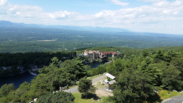
| Looking at Alander Mountain and the rock outcroppings on the ridge. I just came from there! |


Reaching the summit's rock cairn and flagpole, I was surprised to see a group of para-gliders. Similar to hang-gliding, para-gliding uses a smaller vehicle that you sit on top of as opposed to hanging from. You deploy your parachute and lay it out neatly behind you before taking a running leap off the mountain. I think I have added it to my bucket list.


After Brace Mountain, backtrack to the trail intersection and make a right onto the Red Mt. Frissel Trail. Proceed on this red trail, past the Ashley Hill intersection (you will come back to take this trail).
 |
| Take the Red Mt. Frissel Trail to the Boundary Monument |


After you've snacked and rested, retrace your steps to the Ashley Hill Trail and make a right. The trail becomes very easy and level. If you are running low on water or are empty, there will be opportunities to drink and fill from Ashley Hill Brook, parallel to the trail.
Continue on the Ashley Hill Trail for 2.4 miles until you reach the Charcoal Pit Trail. Turn right here and endure just a little more incline before you reach the Alander trail once more. Make a right towards the park HQ as it suggests; another half mile and you are back at the parking lot.

Hi, this a nice write up. I'm planning to this trip in a couple of weeks and like to ask where did you start your hike and where did you parked overnight? Thanks and more power.
ReplyDeleteHey Joniel, thanks for reading! Copy and paste these coordinates into Google Maps 42.085823,-73.462174. I also have the street address at the top of this post. That is the parking lot where I started and left my car overnight. There is a campsite about 1.5 miles from the lot. Have fun!
ReplyDeleteFor a nice view after CT high point on Frissel trail, go another 200 feet to a ledge overlook.
ReplyDeleteYour blog always inspire me to live a life full of transcending adventure! Many thanks!
ReplyDeleteReference: https://homeia.com/city-living-guide/what-is-it-like-to-live-in-washington-dc/