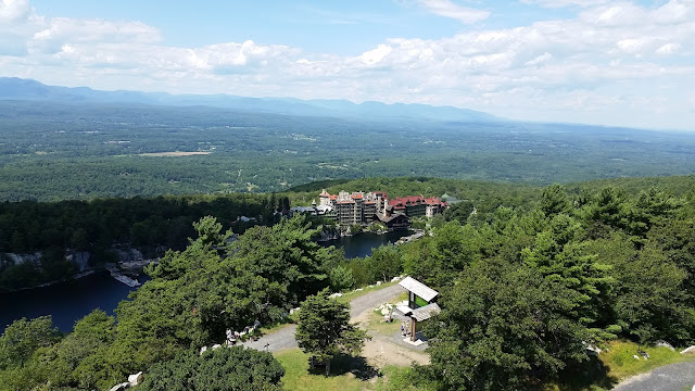
Breakneck - Sugarloaf Loop
A great loop hike encompassing the Breakneck rock scramble and Sugarloaf Mountain
Parking: Southbound and northbound side of Route 9D, 1/4 mile north of the trailhead
Miles: 6
Hours: 3-4
What I took:
Begin climbing immediately from the roadside
and up over the tunnel onto the open
rock of Breakneck Ridge. Follow the
White trail markers. There are a number
of routes along the trail to climb – choose the one that suits you. You will notice signs and X markers that
denote the easier way up. After a few
minutes you will start to get some nice views across the river of Storm King
Mountain.
There will be 4 scenic ledges before the Red Breakneck Bypass trail. Each is marked with a sign noting the elevation; the first is the flagpole. Stop to have some water, a quick snack or just enjoy the view as you catch your breath. Continue on your climb to the next 2 viewpoints.
After reaching the third scenic point, the trail will get a bit gentler as you reach the Yellow Undercliff Trail. Keep moving on the White trail to the last scenic spot. It is not the greatest, but still a nice view and place to rest. After 10 minutes or so you will come to the Breakneck Bypass. Proceed to the right on the White Breakneck Ridge Trail.
The White Breakneck trail will soon merge with the Blue Notch Trail. For the next mile or so the trail is mostly rocky, semi-level and uneventful.
After that mile, you may notice the trail appears to resemble a woods road. This is the approach to your left turn. Trail markers and a small white sign will call out the way to the Yellow Wilkinson trail. Follow this route for a minute or two, and make another left onto Yellow Wilkinson where a cairn has been placed.
Rolling and Rocky terrain will make up the next 1 ½ - 2 miles. The trail will skirt along a dry stream bed, crossing other dry creeks. Keep an eye on the path at your feet, as the trail markers are a little far between. When you begin to notice the trail move away from the stream bed, you will start to climb to the summit of Sugarloaf Mountain. Here, you will get a great view of the Newburgh-Beacon Bridge. A few minutes down the line yields another fantastic view. There is a large cairn and a very distinctive dead tree to mark the spot.
Parking: Southbound and northbound side of Route 9D, 1/4 mile north of the trailhead
Miles: 6
Hours: 3-4
What I took:
- 2L water
- snacks
- daypack or smaller
- first aid
- knife
- tape
- headlamp
- compass
- map - New York New Jersey Trail Conference #102
- synthetic clothing
- hiking boots or trail running shoes
- NO COTTON - Why no cotton? Cotton is a thicker material and isn't as breathable as synthetic materials. Once its wet, it becomes heavier and takes longer to dry.
This loop starts on the iconic Breakneck Ridge rock scramble
and continues around to the Wilkinson trail and Sugarloaf Mountain. There are open views for the first ¾ mile and
a few other viewpoints later in the hike.
Begin climbing immediately from the roadside
There will be 4 scenic ledges before the Red Breakneck Bypass trail. Each is marked with a sign noting the elevation; the first is the flagpole. Stop to have some water, a quick snack or just enjoy the view as you catch your breath. Continue on your climb to the next 2 viewpoints.
After reaching the third scenic point, the trail will get a bit gentler as you reach the Yellow Undercliff Trail. Keep moving on the White trail to the last scenic spot. It is not the greatest, but still a nice view and place to rest. After 10 minutes or so you will come to the Breakneck Bypass. Proceed to the right on the White Breakneck Ridge Trail.
The White Breakneck trail will soon merge with the Blue Notch Trail. For the next mile or so the trail is mostly rocky, semi-level and uneventful.
After that mile, you may notice the trail appears to resemble a woods road. This is the approach to your left turn. Trail markers and a small white sign will call out the way to the Yellow Wilkinson trail. Follow this route for a minute or two, and make another left onto Yellow Wilkinson where a cairn has been placed.
Rolling and Rocky terrain will make up the next 1 ½ - 2 miles. The trail will skirt along a dry stream bed, crossing other dry creeks. Keep an eye on the path at your feet, as the trail markers are a little far between. When you begin to notice the trail move away from the stream bed, you will start to climb to the summit of Sugarloaf Mountain. Here, you will get a great view of the Newburgh-Beacon Bridge. A few minutes down the line yields another fantastic view. There is a large cairn and a very distinctive dead tree to mark the spot.
The descent that follows is steep and rocky, so be wary of
your footing. After a little less than ½
mile you’ll see the intersection of the Breakneck Bypass. Another 10-15 minutes and you are back on
route 9D a ¼ mile north of your car.


Comments
Post a Comment